Block 2, Providence Hall Trust Property: Archaeological BriefingBlock 2 Lots 251-253
Colonial Williamsburg Foundation Library Research Report Series - 1684
Colonial Williamsburg Foundation Library
Williamsburg, Virginia
2002
Block 2, Providence Hall Trust Property: Archaeological Briefing
Principal Investigator
Marley R. Brown III
Colonial Williamsburg Foundation
Department of Archaeological Research
March 1988
Re-issued
December 2001
| Page | |
| List of Figures | ii |
| List of Tables | ii |
| Acknowledgments | iii |
| Introduction | 1 |
| History of the Property | 1 |
| 18th Century | 2 |
| 19th Century | 5 |
| 20th Century | 7 |
| Parking Lot Construction | 7 |
| Previous Archaeological Investigations | 8 |
| 1941 Investigations | 8 |
| 1946 Disturbance of Structure H 1 | 11 |
| 1968 Rescue Archaeology | 12 |
| 1968-1986 Archaeological Activities | 15 |
| 1987 Archaeological Monitoring | 15 |
| Recommendations | 16 |
| Bibliography | 18 |
| Page | |
| Figure 1. Approximate boundary of Virginia Haughwout trust property | 1 |
| Figure 2. Adaptation of the Bucktrout map of 1800 | 2 |
| Figure 3. Desanddrouins map | 4 |
| Figure 4. Frenchman's Map of 1781. | 5 |
| Figure 5. Layout of buildings to east of Chiswell House | 6 |
| Figure 6. Structural remains on colonial lots 251, 252 and 253 | 9 |
| Figure 7. Brick cellar of Structure H-1 | 9 |
| Figure 8. Structure H-1 as revealed in 1941 excavation | 10 |
| Figure 9. Back stoop of Structure H-1 | 12 |
| Figure 10. Sketch map done by J. M. Knight during shop construction | 13 |
| Figure 11. Features excavated in 1968 | 14 |
| Page | |
| Table 1. Ownership of colonial lots 251, 252 and 253 | 3 |
Acknowledgments
Hannah McKee prepared the excellent graphics for this report, and was also instrumental in the final report preparation and assembly. Tamera Mams provided help with the report photographs. I would also like to thank Mrs. Anne Cutler for calling this property to the attention of the Department of Archaeological Research.
Introduction
The purpose of this briefing is to explore the history of that portion of the Providence Hall Trust property which falls within the Colonial Williamsburg Foundation Historic Area, tracing its past owners, the structures built and modified there through time, and its current condition. The property in question fronts along the south side of Francis Street, in Block 2 of the Colonial Williamsburg Foundation Historic Area (Block and Building Book). Currently leased by the Foundation from the Providence Hall Trust, it is now serving as a parking area for guests at the King's Arms Tavern and the future Shields Tavern (Figure 1). Upgrading of the parking lot in connection with the Shields Tavern construction prompted the preparation of this document, one of the purposes of which is to determine if work in the parking lot damaged or destroyed significant archaeological remains.
History of the Property
The portion of the Providence Hall Trust property discussed in this report, measuring 253' east-west and 200' north-south, encompasses Colonial Lots 251, 252 and 252 as shown on the Bucktrout Map of 1800 (Figure 2). Much of the 18th- and 19th-century history portion of this text has been compiled from research reports prepared by Colonial Williamsburg staff members (Stephenson 1959; Stephenson n.d.; Bullock 1958) and information which has come to light since their preparation.
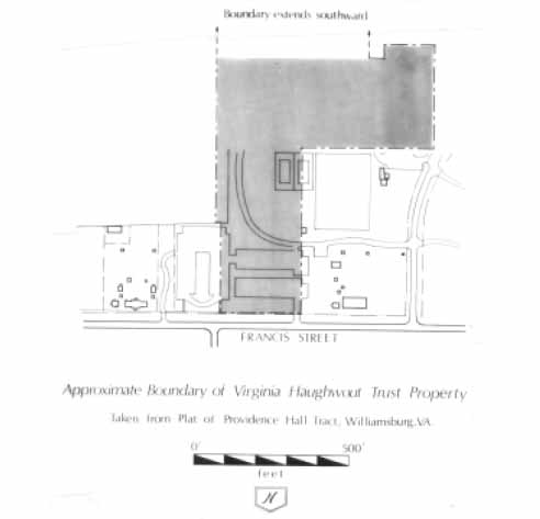 Figure 1.
 Figure 2. Adaptation of the Bucktrout map of 1800.
18th Century
Unfortunately, little is known of the 18th-century history of Colonial Lots 251-253, since all official records for James City County were destroyed during the Civil War. Beginning in the late 18th century, however, owners for these lots can be identified and traced through to the 20th century (Table 1).
From what little can be determined about the southeast side of Williamsburg during the 18th century, it seems that this end of town, on the south side of Francis Street, was characterized by large urban estates. Francis Street formed the southern boundary for the town and here a landowner would purchase a block of lots, construct a home, outbuildings and perhaps formal gardens to form an estate along the fringes of town. For example, Colonel Philip Johnson owned some 950 acres along the southern limits of town. On four town lots adjoining this acreage, he built a two-story frame house (now known as Bassett Hall) sometime after 1753. The Benjamin Waller House and grounds has been reconstructed to reflect the ownership of Williamsburg attorney Benjamin Waller. In addition to his house and its attendant outbuildings, the property also contained Waller's office and an extensive formal garden.
3| Time Period | Owners |
| Pre 1774 | Philip Ludwell Grymes |
| 1774-1782 | James Hubard |
| 1782-by 1810 | Frances Hubard, widow |
| By 1810-1812 | Benjamin Bucktrout |
| 1812-1834 | Mary Bucktrout, widow |
| 1834-1866 | Richard Bucktrout |
| 1866-? (Lots 251, 252) | William and Delia Braithwaite |
| 1866-1893 (Lot 253) | William and Mary E. Wooten |
| 1893-c. 1918 | William Braithwaite |
| 1918-1938/9 | Paul and Ruth Braithwaite Peebles |
| 1938/9-1958 | Virginia Haughwout |
| 1958-present | Providence Hall Trust (portion leased to CWF) |
Similar development appears to have been taking place on Colonial Lots 251-253. Late 18th-century maps of Williamsburg, such as the Desandrouins Map, show what appears to be formal gardens and several buildings in this area (Figure 3). The Frenchman's Map (1781), from the same period, depicts five buildings aligned with Francis Street (Figure 4). Other contemporary maps (St. Simons 1781; Berthier 1781) do not provide much detail about the property in terms of the presence and location of buildings.
The first documented owners of these lots is Philip Ludwell Grymes and his wife Judith Grymes, who lived in Middlesex County, sold Colonial Lots 251, 252, and 253 to James Hubard in November of 1774:
…confirms unto the said James Hubard his heirs and assigns forever, all that Messuage or Brick dwelling House situate on the South side of Francis Street in the City of Williamsburg, also three Lots of land on which or one of them the said dwelling House standeth and which said Lots of Land are discribed [sic] in the plan of the said City by the figures 252. 801. and 253 and all houses outhouses buildings on the said Lots… (Grymes n.d.).
It is not known how long Grymes had owned the property, but since he is shown as living at Brandon Plantation in Middlesex County, it is likely that he only used his Williamsburg property during visits to the colony's capitol. He may have, on the other hand, rented out his Williamsburg property. From the deed, we learn that the home on these lots was constructed of brick. In addition to the house, a range of outbuildings (kitchen, smokehouse, dairy, and possibly a stable and laundry) would have been necessary and were most likely constructed there.
James Hubard, a Williamsburg lawyer, and his family, may have moved into the brick house on Francis Street soon after its purchase, or they may have stayed on at their property on the west side of town, at Green Hill (Stephenson 1959:2). Hubard, a Tory, left Williamsburg and sailed with the British to New York, where he died in
4
 Figure 3. Desandrouins map.
1782. Hubard's widow and her household, described in 1782 as containing "six whites and twelve blacks" (Virginia 1908)
continued to live in Williamsburg until the end of the 18th century. In July of 1782, she sold the Green Hill lots to Judge Joseph Prentis and may have moved to Francis Street at this time. The years after her husband's death were obviously not easy one for Frances Hubard. Personal property records taken between 1783 and 1800 show her as owning a steadily decreasing number of slaves and livestock. To make matters worse, in April 1797, a fire consumed her house and most of her clothing and furniture was destroyed (Virginia Gazette, April 8, 1797).
Figure 3. Desandrouins map.
1782. Hubard's widow and her household, described in 1782 as containing "six whites and twelve blacks" (Virginia 1908)
continued to live in Williamsburg until the end of the 18th century. In July of 1782, she sold the Green Hill lots to Judge Joseph Prentis and may have moved to Francis Street at this time. The years after her husband's death were obviously not easy one for Frances Hubard. Personal property records taken between 1783 and 1800 show her as owning a steadily decreasing number of slaves and livestock. To make matters worse, in April 1797, a fire consumed her house and most of her clothing and furniture was destroyed (Virginia Gazette, April 8, 1797).
 Figure 4. Frenchman's Map of 1781.
19th Century
The Bucktrout Map (1800) shows Colonial Lots 251 and 252 as belonging to Hubard, but by 1810, these lots, in addition to 253 and 254, had been purchased by Benjamin Bucktrout. Bucktrout, a cabinetmaker, died in 1812, and his widow owned these lots until her death in 1834. Richard, the son of Benjamin and Mary Bucktrout, became the owner of this property. Oral histories taken with elderly Williamsburg residents in the first part of the 20th century reveal that Richard Bucktrout was an undertaker and that he owned and ran a coffin shop in this area (Charles 1928; Peebles 1931; Vandergrift 1928). After his death in 1866, the property was contested in court and was divided into three portions. The third of the property encompassing Lots 251 and 252 was awarded to William H. and Delia Braithwaite (formerly Delia Bucktrout) (Stephenson n.d.:6). The eastern portion was given to William and Mary Elizabeth Wooten, who, in 1893, sold their portion of the fifteen acres to William Braithwaite (Stephenson n.d.:10).
Oral history recollections reveal that in the latter part of the 19th century, there were several small outbuildings on Lots 251-253 (Stephenson 1964). It was felt that these dated to the 18th, or possibly the 19th century, and that some of these buildings may have been incorporated into some of the buildings standing in the early 20th century. Not all of the oral histories agree in the exact placement, numbers and use of the buildings on these three lots, although Bullock (1958) seems to feel that Mrs. Haughwout's recollections are the most complete, and fit the archaeological record with the most accuracy (Figure 5). Her recollections are of the Colonial Lots 251-255 area around the end of the Civil War.
6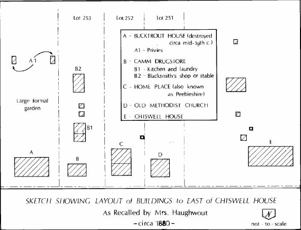 Figure 5.
Lot 251
Mrs. Virginia Haughwout remembered that a Methodist Church stood on Lot 251 when she was a child just after the Civil War (Bullock 1958:2). From her recollections, this building was in poor condition at the time.
Lot 252
A small story and a half structure, later known as the Homeplace (or Peebleshire) stood on this lot during the latter half of the 19th century. William Braithwaite added a rear addition to the Homeplace, and added a second floor to the building shortly after acquiring it in 1893. This and the kitchen/laundry building on the lot to the east (253) were used by the Braithwaite family during the time they lived on Francis Street (Haughwout 1941).
Lot 253
According to Mrs. Haughwout, Lot 253 contained a greater number of buildings than Lot 252 during the last half of the 19th century. On the northern edge of the lot stood a drug store with a full basement. A combination kitchen and laundry building, perhaps once associated with the old Bucktrout House on Colonial Lot 254, was located south of the store. The kitchen contained a storage pit beneath its floor. A stable, blacksmith shop and a powder mill were components of this lot.
20th Century
Much of the information which can be derived about this area in the 20th century comes from oral history, official Colonial Williamsburg Foundation documents, and from photographs.
Colonial Lots 251, 252, and 253 have never been owned by the Colonial Williamsburg Foundation, having instead remained in the hands of Bucktrout family members (the Braithwaites, Haughwouts and Cutlers). Throughout the first half of the 20th century, these lots saw a multitude of uses, both domestic and commercial. Mrs. Peebles moved to a new home on Lot 253 around 1928, and turned the Homeplace into four apartments (Cutler 1988). During the time it was rented, the house was known as Peebleshire. The Homeplace remained rental property throughout World War II, after which it served both as an antique shop and as apartments (Cutler 1988). Mrs. Haughwout recalls a well southwest of the Homeplace. A wellhouse was constructed over this well by Mrs Haughwout (Cutler 1988).
Anne Cutler owned an antique shop in the Homeplace from the end of World War II until 1965. She recalled that some disturbance to archaeological layers or features occurred when the shop was removed. In 1946, a gift shop (known as Bozarth's from 1946-1953 and later as Mr. Foster's Gift Shop) was constructed on Colonial Lot 251. The construction of this shop disturbed archaeological remains in this area and this will be discussed in the next section of this briefing.
Colonial Lots 251-253 were leased to the Colonial Williamsburg Foundation in 1966 by the trustees of the Providence Hall Trust under the will of Virginia B. Haughwout as part of a larger tract of land known as the Providence Hall Trust Property (Chancery 16:689). The Foundation retains a hundred year lease on the Providence Hall Trust Property. At the expiration of the Providence Hall Trust at the death of the last granchild of Virginia Haughwout, the property will revert to the Bucktrout-Braithwaite Memorial Foundation.
Parking Lot Construction
The first mention of using the property between the Semple House and the Chiswell-Bucktrout House as a parking lot came in 1953. In May of that year, A. E. Kendrew proposed to John D. Rockefeller, Jr. that a new temporary parking area on the south side of Francis Street, south of the Capitol, would relieve parking congestion in that area (Kendrew 1953a). Although Rockefeller was reluctant to put a parking lot in this area, since he felt parking facilities at the proposed Information Center would alleviate the problem (Rockefeller 1953), he had obviously agreed to this solution by the end of the year (Kendrew 1953b). Plans for the parking lot proceeded rapidly, and it had been completed by the first part of October 1954 (Hackett 1954a). This construction took place on Colonial Lots 254, 255, and what was known as the Morris property, directly west of the William Finnie (Semple) House. Here, archaeology done by James Knight had located a large number of buildings, some of which corresponded to structures remembered by Virginia Haughwout. In order to construct 8 the parking lot, some mechanical grading was necessary, as well as the planting of shrubs, the installation of gravel walks, fences and storm drains (Hackett 1954b). Although the Francis Street parking was intended to be a temporary measure, it was never removed, and was finally paved in 1963 (CER 1963). The grading connected with the parking lot construction altered the drainage pattern on the property, causing flooding of the houses on Colonial Lots 252 and 253 (Cutler 1988).
By 1968, the ninety car parking lot which had been constructed in 1954 was inadequate, and an additional fifty spaces was proposed (Project 1968). This parking area was to be constructed to the west of the existing parking, on the location of the former Homeplace and Mr. Foster's Shop (Colonial Lots 251 and 252). Forty-nine additional parking spaces in the same area were created in 1971, with screen planting and lighting an integral part of the construction of these spaces (CER 1971). This is how the lot remained until 1987, when the Colonial Williamsburg Foundation upgraded the parking lot in conjunction with the Shields Tavern reconstruction.
Previous Archaeological Investigations
Archaeological investigations of varying degrees have been conducted in the area which now serves as the parking lot on several occasions. By no means has this coverage been complete, and from all indications in the documentary record, as well as the archaeological record, this area does hold potential for revealing further information about its use in the 18th century.
1941 Investigations
An intensive effort to locate the foundations of structures which once stood on portions of Block 2 was mounted by the Colonial Williamsburg Foundation in 1940 and 1941. Archaeologist James M. Knight and his crew used the technique of cross-trenching to excavate Colonial Lots 249, 250, 254, and 255 during that year. This technique, which used a series of one foot wide trenches spaced evenly over the property, was designed to quickly and efficiently locate buildings with brick foundations. A number of structures were located on these lots (Figure 6) in this fashion, and a brief report on these excavations was prepared (Duke 1941).
Colonial Lots 251, 252, and 253 were not archaeologically examined at this time, since they were owned by Virginia Haughwout. The archaeological investigation of Colonial Lot 250 (which is part of the Chiswell-Bucktrout property), however, has direct bearing upon the archaeological significance of Colonial Lot 251. Reports prepared after the excavation of the Chiswell-Bucktrout property (Duke 1941), and recent interviews with James M. Knight (Knight 1982, 1983), reveal that a large structure straddled the property line between Colonial Lots 250 and 251. Designated H-1 in the report, this structure contained a brick cellar which was half excavated by Knight and his crew in 1941 (Figure 7). It appeared to have been destroyed by fire around the end of the 18th century, and it was speculated that this was the Hubard house that had been burned in 1797. The remainder of the house,
9
 Figure 6. Structural remains on colonial lots 251, 252, and 253.
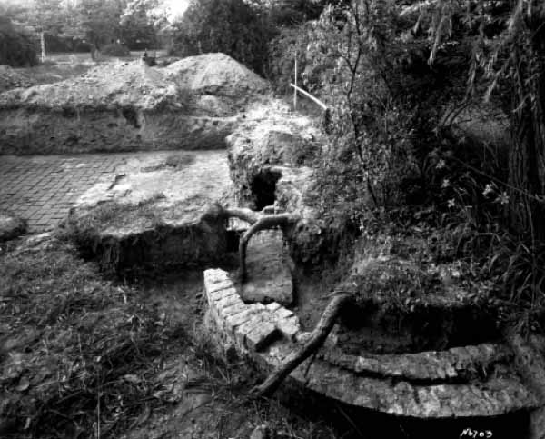 Figure 7. Brick cellar of Structure H-1.
10
located on the property of Virginia Haughwout (Lot 251), was left unexcavated. The north wall of Structure H-1 was set back from Francis Street almost 81 feet.
Figure 7. Brick cellar of Structure H-1.
10
located on the property of Virginia Haughwout (Lot 251), was left unexcavated. The north wall of Structure H-1 was set back from Francis Street almost 81 feet.
Some details about Structure H-1 were apparent through its partial excavation conducted by James Knight (Figure 8). This structure was believed to measure 23' NS × approximately 64' EW, and architectural remains recovered from the cellar fill included fragments of dressed stone, rubbed brick and marble, indicating a degree of wealth and elegance in the building's construction. The cellar itself, which appeared to have been an English basement, was partially paved with 9" brick tiles and some regular brick. Burned ceramics within the cellar fill indicate that the building was burned after 1790, supporting the hypothesis that this structure actually represents the Hubard House. Also common in the cellar fill were tools associated with gardening (Goodwin 1941).
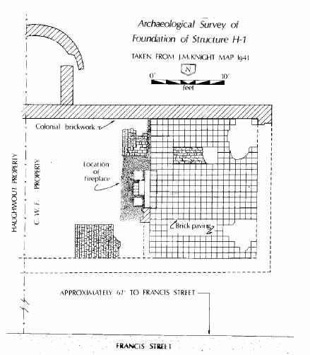 Figure 8. Structure H-1 as revealed in 1941 excavation.
The cellar fill extended five feet below the present ground surface, and in addition to this cellar, there is some indication of an addition to the south, forming a T-shaped building plan (Bullock 1958). A semicircular brick foundation, also on the south side of the cellar, may have indicated the seating for a back stoop (Figure 9). The building, which contained an interior chimney, had foundation wall over 21" thick and certainly represented a brick structure of more than one story in height.
It was reported in the 1941 summary of excavation that there was no structure corresponding to the location of Structure H-1 shown on the Frenchman's Map of 1782. It was also stated that close examination of the Frenchman's Map, however, showed pin pricks denoting the corners of a building in the location of Structure H 1, therefore explaining its absence on the map. Re-examination of the Frenchman's Map, particularly in light of building foundations revealed in the 1941 excavation (Duke 1941) indicate that Structure H-1 may be recorded on the map after all (Figure 6). If this is indeed the case, then the Frenchman's Map shows four additional buildings on this property; three to the east of the Hubard House (Structure H-1) and one lying directly west. The western structure may represent the Chiswell-Bucktrout Kitchen), while later (1946) construction on the lot appears to have discovered one of the eastern buildings (Knight 1946).
One troubling aspect, and perhaps the source of confusion (a lengthy discussion of which is found in Duke 1941), about the Frenchman's Map and Structure H-1, is the discrepancy in the property/lot boundaries between 18th- and 20th-century maps. If the present day boundaries between the Providence Hall Trust and Colonial Williamsburg properties is believed to represent the dividing line between Colonial Lots 250 and 251, then it appears that Structure H-1 actually straddled two colonial lots. Documentary evidence suggests that these lots would have had separate owners all through the period that the Hubard House was in existence. No documentary references exist for the owners of 251-253 until the third quarter of the 18th century, so perhaps the lots were part of one parcel earlier in the 18th century.
The Chiswell-Bucktrout property was restored to its 18th-century appearance during 1950 and 1951, but Structure H-1, and Colonial Lots 251-255 were left unrestored. Despite the archaeological cross-trenching done in 1941, the Foundation obviously did not feel secure enough to restore this area, as A. E. Kendrew pointed out when arguing for the necessity of constructing parking on Block 2. His memo to the files stated: "We also reviewed the fact that the reconstruction of colonial buildings on this property had been deferred because of lack of evidence as to their original design" (Kendrew 1953b) . Since this property was not highly documented, either through records or archaeological remains, he felt that using it for parking rather than as an exhibit area was justified.
1946 Disturbance of Structure H-1
During 1946, the unexcavated portion of Structure H-1 was slightly damaged by the construction of Mr. Foster's Gift Shop on Colonial Lot 251. Archaeologist James Knight visited the site to inspect the damage, but found that the already laid new
12
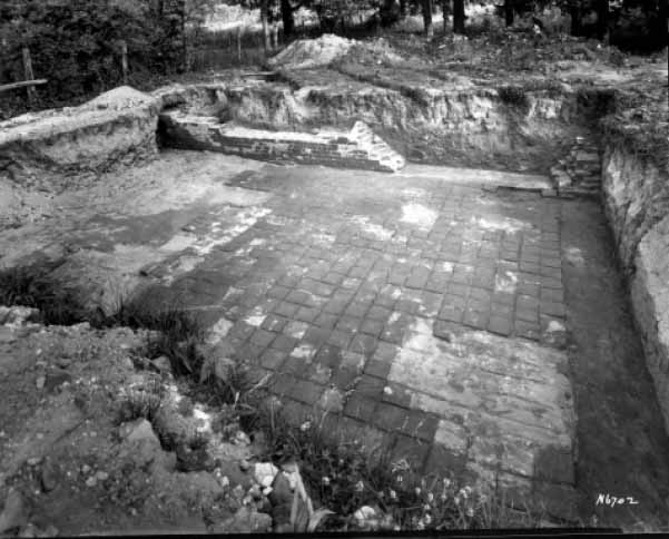 Figure 9. Back stoop of Structure H-1.
foundation walls (Figure 10) obscured any signs of the 18th-century brick building above which the shop had been constructed (Knight 1946). The general contractor for the job assured Knight, however, that the concrete foundation walls of the shop were not set deeply into the ground and had not significantly damaged the foundation of Structure H-1 (The contractor's statement was proven correct during the 1968 archaeological examination of the property).
Figure 9. Back stoop of Structure H-1.
foundation walls (Figure 10) obscured any signs of the 18th-century brick building above which the shop had been constructed (Knight 1946). The general contractor for the job assured Knight, however, that the concrete foundation walls of the shop were not set deeply into the ground and had not significantly damaged the foundation of Structure H-1 (The contractor's statement was proven correct during the 1968 archaeological examination of the property).
Another building with a 9" brick foundation was also disturbed by the construction of Mr. Foster's Shop. This foundation wall, running east-west, was located at the southeastern corner of the Gift Shop, and was identified, on the basis of brick size, color, and mortar type, as dating to the 18th century (Bullock 1958). A building was depicted in this location on the Frenchman's Map.
1968 Rescue Archaeology
Prompted by the proposed expansion of the parking lot into Colonial Lot 251, Mr. Foster's Shop was moved from its Block 2 location in 1968. At this time, a short archaeological rescue project was conducted by the Department of Archaeology, under the direction of Ivor Noël Hume. The 1968 work was very limited in scope, but did produce some interesting results (Frank 1968). Only those areas which were disturbed by the removal of the Gift Shop were examined during this eight-day investigation (Figure 11).
13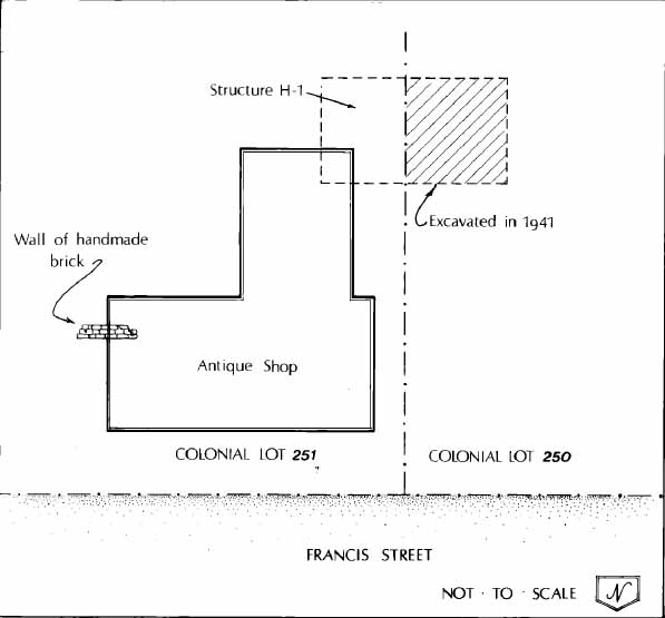 Figure 10. Sketch map done by J.M. Knight during shop construction.
In order to move the building, trenches were excavated by the building contractors for the placement of cross-beams beneath the structure. Only two of these trenches cut through intact 18th-century strata (Frank 1968:3). Additionally, four 4' square holes were excavated at the interior corners of the gift shop. Only one of these pits caused any damage to archaeological remains. This pit, in the southwest corner of the gift shop, extended into the rubble filled cellar of Structure H-1. Numerous artifacts were removed from this pit, including architectural material such as window bars and hinges, cooking implements, and ceramic tablewares (Frank 1968:3,4). Probing along the southern wall in 1968 revealed that Structure H-1 measured approximately 65' in length, making the size of the building very close to James Knight's original estimate of 23' × 64'. Knight's excavation removed the western 34' of cellar fill, thus leaving the 31' of building which stretches into Colonial Lot 251 virtually untouched.
The shallow brick foundation wall disturbed by the gift shop construction in 1946 was also re-examined in 1968. No evidence for the dating of this structure was obtained at this time, but a structure was shown here on the Frenchman's Map,
14
 Figure 11. Features excavated in 1968.
suggesting that it was standing during the late 18th century. The 1968 archaeological report concluded: "The 1946 construction of the Foster Shop and its subsequent removal in 1968 apparently disturbed only a small portion of the Hubard House's remains. The recovery of so many important artifacts during the limited 1968 archaeological work would suggest that a proper excavation of Lot 251 could be most rewarding." (Frank 1968:8).
Figure 11. Features excavated in 1968.
suggesting that it was standing during the late 18th century. The 1968 archaeological report concluded: "The 1946 construction of the Foster Shop and its subsequent removal in 1968 apparently disturbed only a small portion of the Hubard House's remains. The recovery of so many important artifacts during the limited 1968 archaeological work would suggest that a proper excavation of Lot 251 could be most rewarding." (Frank 1968:8).
During the parking lot expansion into Lots 251 and 252 in 1968, the archaeological sensitivity of the area was recognized and taken into account during the planning phases:
The new parking area will be installed above the present surface so as not to disturb known archaeological evidence or intrude drastically in areas which have not been investigated (Project 1968).This suggests that no machine grading took place and that Structure H-1 survives intact below the base of the parking lot. The l984 excavations at Tazewell Hall demonstrated that mechanical stripping in conjunction with parking lot construction virtually destroys all but the deepest-set archaeological features (Samford and Brown 1986).
1968-86 Archaeological Activities
Although no real archaeological investigation of the remaining leased Providence Hall Trust property has occurred since 1968, the Archaeology Department conducted spot checks of the area during any construction activities in the area. For example, the July 1971 Monthly Report on Archaeological Activities stated:
The current clearing of the Haughwout property (Hubbard) for construction of the new Inn units revealed traces of eighteenth and early nineteenth century occupation in the extreme south east [sic] corner of the cleared area, but as yet no structural remains have been encountered.
Again, in 1975, archaeological monitoring of the tennis court construction on Colonial Lot 251 revealed a small number of colonial artifacts (Monthly Report 1975). Although fence and ditch lines connected with the projected 18th century garden were expected, no such features were revealed through this limited project.
Both of these projects suggest that significant archaeological remains may exist over the entire Providence Hall Trust property.
1987 Archaeological Monitoring
Upgrading of the parking lot in connection with the Shields Tavern construction began in 1987. After notification, the Department of Archaeological Research monitored the digging of trenches in association with the planting of trees and shrubs. Several trenches were mechanically excavated in the median areas of the lot, but examination of these trenches showed that very little, if any damage was done to the majority of the area (Edwards 1987). The areas examined showed that the machine operator had removed approximately a foot of asphalt and orange sandy clay fill associated with the parking lot construction. In a trench located 75' west of the Finnie House, beneath this clay fill was an intact deposit of 18th-century soil. Although this layer of soil may have been truncated during the parking lot construction, it was not significantly harmed by the 1987 excavation.
A 40' long trench, running east-west parallel to Francis Street was also cut through Lots 254 and 255. This trench, which measured approximately 12' NS at its widest point, contained a two concentrations of brick rubble (there was no indication of intact brickwork), as well as 18th-century ceramics, nails and glass. Excavation maps show numerous structures located along Francis Street in this area.
The only structural remains which were disturbed by this trenching were located just west of the Finnie House in an area shown as a street on the Bucktrout Map. Here, a portion of a single brick wide foundation was uncovered and mapped by the archaeological monitors. The brick showed signs of sand mortar, a type commonly associated with buildings whose construction dates to the 19th century. This appeared to be a small outbuilding of some kind, based on the insubstantial nature of the foundation. The exact size of the building was not evident, and neither were any artifacts which would aid in dating the structure.
Recommendations
The property in question represents the estate of a wealthy family living on the outskirts of town in the late 18th century. If the Foundation's statement about the parking lot construction being conducted in such a way that would have left the archaeological remains of Structure H-1 undamaged is correct, then there is excellent archaeological potential for this structure on Colonial Lot 251. Archaeological techniques have changed drastically since the 1941 excavation, and would be able to provide detailed information about the property that was not forthcoming from the small portion of the site excavated in 1941. The age of the Structure H-1 could be addressed, as well as the presence of outbuildings to the south and east. Although Knight's cross-trenching techniques were good at locating structures which contained brick foundations, these trenches usually missed structures which had been set on brick piers or had been supported on wooden posts buried in the ground. With today's techniques, information concerning the spatial arrangement of the lot and the concentrations of certain activities in specialized locations could be accomplished. Of particular interest is the abundance of garden tools which were recovered from the cellar in the 1941 excavation. These tools, plus the depiction of what appears to be a large garden behind the house on the Rochambeau Map, hold interesting possibilities for uncovering the remains of formal and vegetable gardens, perhaps similar to those expected at the John Custis House on the western end of Francis Street.
Also of interest is the documentation that Frances Hubard's economic position changed drastically in the period from her husband's death until the beginning of the 19th century. Archaeological investigations on the property could document this decline and contrast it with earlier assemblages from the household's wealthier period.
Not only would it be expected that the excavations would locate Structure H-1, but the precautions taken to insure the archaeological integrity of this building would have also preserved other archaeological features and layers intact. For example, if Structure H-1 was not actually shown on the Frenchman's Map, but was instead represented by pinpricks, then five other structures are shown standing of Colonial Lots 251 and 252 at the end of the 18th century. The garden remains shown on the Rochambeau Map may also be evident to the south of these structures. The potential for archaeological remains on all three of these lots is excellent.
Although not in an area affected by the parking lot, the Bucktrout-Braithwaite family cemetery is located approximately 600' south of Francis Street. Oral tradition states that this cemetery was used for the burial of public charges, blacks, and Revolutionary War soldiers. Professor Paul Peebles, when interviewed in 1931, stated that he had recently cleared the cemetery area and located the remains of approximately 50 graves, some of which contained bones (Stephenson 1964). At least one grave has been added since 1931, and a recent cursory examination of the area showed several shallow depressions representing graves.
In summary, Colonial Lots 251, 252, and 253 of the Providence Hall Trust property represents a rare opportunity to examine archaeological remains which have 17 not been examined through prior archaeological research. Due to records lost during the Civil War, little is known about this portion of Williamsburg. The chance to investigate pristine 18th-century structures on Colonial Lots 251-253 would be ideal for providing information about this little known area and its residents. It is strongly recommended that archaeological investigations be conducted in this area prior to any additional ground disturbing activity taking place here.
Bibliography
- 1800
- Plan of the City of Williamsburg. Map on file, Research Library, Colonial Williamsburg Foundation, Williamsburg, VA.
- 1958
- Report on Colonial Lots 251, 252, and 253. Unpublished report prepared by the Department of Architecture and on file at the Foundation Library, Colonial Williamsburg Foundation.
- 1963
- Capital Expenditure Request for South Capitol Parking Area, Block 2. On file in folder entitled "Block 2, Parking Area, 1951-1966," Department of Archives and Record, Colonial Williamsburg Foundation.
- 1971
- Capital Expenditure Request for Block 2 Parking Area Addition in Southwest Section, dated February 25, 1971. On file in folder entitled "Block 2, Parking Area, 1968-1973." Department of Archives and Records, Colonial Williamsburg Foundation.
- Deed Between Anne Ballard Cutler and Virginia Trust Company and the Bucktrout-Braithwaite Memorial Foundation and Colonial Williamsburg Foundation, dated September 10, 1966. Chancery Order Book 16:689, Williamsburg-James City County Courts, Williamsburg Virginia.
- 1928
- Interview contained within typescript entitled "Recollections of Williamsburg" (1933). Unpublished manuscript on file at the Foundation Library, Colonial Williamsburg Foundation.
- 1985
- Colonial Williamsburg FoundationBlock and Building Book. 8th Revision. Archives and Records Department of the Colonial Williamsburg Foundation.
- 1988
- Interview with Mrs. Anne Cutler by Patricia Samford, May 10, 1988.
- 1781
- Carte des Environs de Williamsburg en Virginie on les Armes Francoise et Americaine ont Campes en September 1781. [By Desandrouins, Enlargement of Williamsburg Area.] Original located in Paris, Ministry of Wars, Service Technique dur Genie # 47, Fascicule 8, Carte #29. Photostat on file, Special Collections, Foundation Library, Colonial Williamsburg Foundation.
- 1941
- Archaeological Report, Chiswell-Bucktrout House, Block 2, Building 17 (Archaeological Area H), July 30, 1941. Unpublished report on file at the Foundation Library, Colonial Williamsburg Foundation. 19
- 1987
- Monitoring Report-Block 2, Area R (Morris), December 21-22. Report on file at the Department of Archaeological Research, Colonial Williamsburg Foundation.
- Contained within Deed Between Anne Ballard Cutler and Virginia Trust Company and the Bucktrout-Braithwaite Memorial Foundation and Colonial Williamsburg Foundation, dated September 10, 1966. Chancery Order Book 16:689, Williamsburg-James City County Courts, Williamsburg Virginia.
- 1968
- The Hubard Site: Archaeological Report of Rescue Work Undertaken in 1968. Prepared by the Department of Archaeology, Colonial Williamsburg Foundation, Williamsburg, VA.
- 1782
- Plan de la ville et environs de Williamsburg en Virginies, 1782. Photostat copy of map on file, Foundation Library, Colonial Williamsburg Foundation, Williamsburg, VA.
- 1941
- Memo to A. E. Kendrew re Block 2, Area H-1. Memo on file at the Foundation Library, Colonial Williamsburg Foundation.
- n.d.
- Deed of Philip Ludwell Grymes to James Hubard. Loose Papers, Fredericksburg District Court, Fredericksburg, VA.
- 1954a
- Memo to A. E. Kendrew re Block 2, Parking Area, dated September 28, 1954. On file in folder entitled "Block 2, Parking Area, 1951-1966," Department of Archives and Records, Colonial Williamsburg Foundation. 1954bMemo to Mr. Campioli re Parking Area, Block 2, Dated January 14, 1954. On file in folder entitled "Block 2, Parking Area, 1951-1966," Department of Archives and Records, Colonial Williamsburg Foundation.
- 1941
- Recollections of Williamsburg. Typescript on file at Research Department, Colonial Williamsburg Foundation.
- 1953a
- Memo to John D. Rockefeller, Jr. dated May 7, 1953. On file in folder entitled "Block 2, Parking Area, 1951-1966," Department of Archives and Records, Colonial Williamsburg Foundation.
- 1953b
- Memo to Files re Parking Lot on Francis Street, dated November 24, 1953. On file in folder entitled "Block 2, Parking Area, 1951-1966," Department of Archives and Records, Colonial Williamsburg Foundation.
- 1941
- Archaeological Survey of the Foundation of Mrs. Frances Hubard's House, Williamsburg, VA. Block 2, Area H-1. Map on file at the Colonial Williamsburg Foundation. Scale ¼" = 1.0'. 20
- 1946
- Sketch showing New Antique Shop now under construction, in relation to remains of ancient foundation wall, July 18, 1946. Contained within Bullock 1958.
- 1982
- Interview with Andrea Foster, dated December 9, 1982. Tape and transcript on file at the Department of Archives and Records, Colonial Williamsburg Foundation.
- 1983
- Interview with Andrea Foster, dated June 22, 1983. Tape and transcript on file at the Department of Archives and Records, Colonial Williamsburg Foundation.
- 1971
- July Monthly Report on Archaeological Activities. On file at the Department of Archaeological Research, Colonial Williamsburg Foundation.
- 1975
- May Monthly Report on Archaeological Activities. On file at the Department of Archaeological Research, Colonial Williamsburg Foundation.
- 1931
- Interview dated February 4, 1931. Copied from card in Research Department headed "Williamsburg Cemeteries."
- 1968
- Project Authorization Parking Area for King's Arms Tavern, Block 2 dated August 29, 1968. On file in folder entitled "Block 2, Parking Area, 1968-1973." Department of Archives and Records, Colonial Williamsburg Foundation.
- 1953
- Letter to A. E. Kendrew, dated May 18, 1953. On file in folder entitled "Block 2, Parking Area, 1951-1966." Department of Archives and Records, Colonial Williamsburg Foundation.
- 1781
- Carte de la Campagne de la Division aux ordres du Mis de St. Simon en Virginie. Ayer Collection, Newberry Library.
- 1986
- Archaeological Excavations on the Tazewell Hall Property. Unpublished report on file at the Department of Archaeological Excavation, Colonial Williamsburg Foundation, Williamsburg, VA.
- 1959
- Lots 251-252, Francis Street, Block 2. Unpublished report on file at the Foundation Library, Colonial Williamsburg Foundation.
- 1964
- Colonial Lots 251-252-253, Block 2, South Side, Francis Street. Typescript written with PB in August of 1964 and on file at the Foundation Library, Colonial Williamsburg Foundation.
- 1964
- Colonial Lots 253-254. Unpublished report on file at the Foundation Library, Colonial Williamsburg Foundation. 21
- 1928
- Williamsburg in 1844. Typescript on file at the Research Department, Colonial Williamsburg Foundation.
- 1908
- Heads of Families…Virginia. Washington: Government Printing Office.
- 1797
- April 8, 1797 edition, Nicolson, editor.